Live Cams
Countries
Featured Cams
Get A Cam
Live Cams
Countries
Featured Cams
Get A Cam
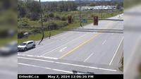
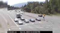
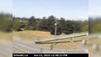
Area A › East: Hwy 1, about 3.7 km south of Bamberton, looking east | Live Webcams
Webcam & Weather Report
See.cam
North America
CA
British Columbia
Area A
Area A › East: Hwy 1, about 3.7 km south of Bamberton, looking east
Current Still
Timelapse
Daylight Still
Webcam was last updated 2 years ago
Rating
Webcam Views
Map
Discuss
See more webcams in
British Columbia
Hazelmere › South: Hwy 15 at 16th Ave, looking south
Radium Hot Springs › South: Hwy 93/95 roundabout, at - looking southbound on Hwy 93/95
Merritt › South: Hwy 97C (Okanagan Connector), at Hwy 5A Junction, near Aspen Grove, looking south
North Kelowna › West: East approach to WR Bennett Bridge at Abbott Street, looking west along Hwy
Lantzville › South: Hwy 19, at Aulds Rd in Nanaimo, looking south
Port Edward › South: Hwy 16 at - arterial road, looking south
Chilliwack › South: Hwy 9, at the north end of Rosedale Overhead, looking south
Prince George › West: Hwy 97 at Hwy 16 in - looking northbound on Hwy
Delta › North: Hwy 17A, at Hwy 10 (Ladner Trunk Rd), looking north
Alpine Meadows › North: Hwy 99 at Alpine Way, looking north
Township of Langley › West: Hwy 1 at 232nd St. overpass, looking west
Fraser Lake › North: Hwy 16 at Stella Road in - looking north
Explore by Continent
Europe
Asia
South America
Oceania
North America
Africa


Discuss