Live Cams
Countries
Featured Cams
Get A Cam
Live Cams
Countries
Featured Cams
Get A Cam
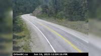
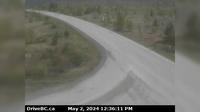
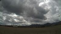
Area C › North: Hwy 27, about 12km south of Fort St. James at Spencer Pit, looking north | Live Webcams
Webcam & Weather Report
See.cam
North America
CA
British Columbia
Area C
Area C › North: Hwy 27, about 12km south of Fort St. James at Spencer Pit, looking north
Current Still
Timelapse
Daylight Still
Webcam was last updated 2 years ago
Rating
Webcam Views
Map
Discuss
See more webcams in
British Columbia
West Lynn › North: Hwy 1, northend of Ironworkers Memorial Bridge at Fern Street northbound
Keremeos › West: Hwy 3A (Kaleden to) - near Sheep Creek Road, looking west
Courtenay › North: Hwy 19A at Ryan Road in - looking northbound
Area C
Fraser › South: FraserCamp
Abbotsford › North-East: Eagle Mountain Park
Pemberton › North: Hwy 99 at Portage Rd in - looking north
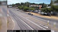
Surrey › East: Hwy 10 at King George Blvd, looking east on Hwy
Gitwinksihlkw › North-East: Hwy 113 at Anlaw Rd, near - within Nisga'a Memorial Lava Bed Provincial Park, looking east
Area E › South-West: Clinton/Bleibler Ranch Airport
Area E › South: Hwy 19 at the Nanoose Rest Area, looking south
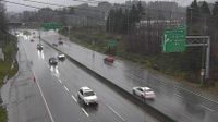
Langford › North: Hwy 1 at West Shore Parkway, looking northbound toward Goldstream Park
Explore by Continent
Europe
Asia
South America
Oceania
North America
Africa


Discuss