Live Cams
Countries
Featured Cams
Get A Cam
Live Cams
Countries
Featured Cams
Get A Cam
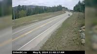
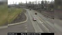
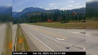
Area C › South: Hwy 27, about 12km south of Fort St. James at Spencer Pit, looking south | Live Webcams
Webcam & Weather Report
See.cam
North America
CA
British Columbia
Area C
Area C › South: Hwy 27, about 12km south of Fort St. James at Spencer Pit, looking south
Current Still
Timelapse
Daylight Still
Webcam was last updated 2 years ago
Rating
Webcam Views
Map
Discuss
See more webcams in
British Columbia
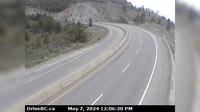
Moyie › North: Hwy 3, near the south end of - Lake, looking north
West Kelowna › East: Hwy 97 at Hwy 97C junction, about 5 km south of Westbank, looking east
Osoyoos › South: US 97 at MP 336.4: (View South)
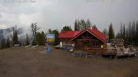
Area F: Panorama - Summit Panorama
Telkwa › South: Hwy 16, in - at Hankin Rd, looking south
Revelstoke
Campbell River: Ferry Cam
Cedarvale › East: Junction of Hwy 16 and Hwy 37, near Kitwanga, looking east on Hwy
Area B
Vancouver › East: Fairview - South Cambie - Mount Pleasant - East Vancouver
Elko › East: Hwy 3, about 1 km west of - at Hwy 93 junction, looking east
Pitt Meadows › South-East: Hwy 7 (Lougheed Hwy) at Kennedy Rd, looking southeast, towards
Explore by Continent
Europe
Asia
South America
Oceania
North America
Africa


Discuss