Live Cams
Countries
Featured Cams
Get A Cam
Live Cams
Countries
Featured Cams
Get A Cam
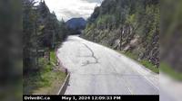
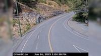
Chapman Camp › South-West: Highway 95A at Black Bear Crescent, about 3 km south of Kimberley looking southwest | Live Webcams
Webcam & Weather Report
See.cam
North America
CA
British Columbia
Chapman Camp
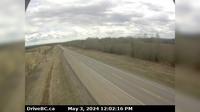
Chapman Camp › South-West: Highway 95A at Black Bear Crescent, about 3 km south of Kimberley looking southwest
Current Still
Timelapse
Daylight Still
Webcam was last updated 2 years ago
Rating
Webcam Views
Map
Discuss
See more webcams in
British Columbia
East Pine › East: Hwy 97 on - Hill, about 27 km east of Chetwynd, looking east
Hilliers › West: Hwy 4 at Alberni Hwy (Hwy 4A) junction, about 2 km west of Coombs, looking west
Area C › South-East: Hwy 3/93 near Ha Ha Creek Road, looking southeast
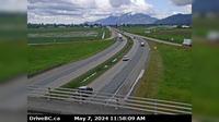
Area B › South: Hwy 5, Great Bear Snowshed looking south
Area B › South: Hwy 1 at Alexandra Bridge, looking south
Chilliwack › West: Hwy 1 at Prest Rd in - looking west
West Vancouver › East: Hwy 1, at Cross Creek/15th St exit in - looking east
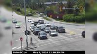
Delta › South: Hwy 17 at 52nd Street, looking south
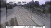
Surrey: SR 543 at MP 0.9: Duty Free
Sooke › North: Hwy 14 at Glinz Lake Road, looking north
Saanich › South: Hwy 17 (Patricia Bay Highway) at Ravine Way, looking south
Pitt Meadows › South: Hwy 7 (Lougheed Hwy) at Harris Road, looking south
Explore by Continent
Europe
Asia
South America
Oceania
North America
Africa


Discuss