Live Cams
Countries
Featured Cams
Get A Cam
Live Cams
Countries
Featured Cams
Get A Cam
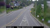
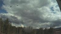
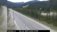
Fraser Valley Regional District › North: , Hwy , km south of Merritt, looking north | Live Webcams
Webcam & Weather Report
See.cam
North America
CA
British Columbia
Coquihalla
Fraser Valley Regional District › North: , Hwy , km south of Merritt, looking north
Current Still
Timelapse
Daylight Still
Webcam was last updated 6 years ago
Rating
Webcam Views
Map
Discuss
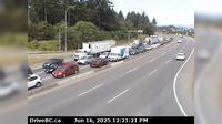
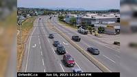
See more webcams in
British Columbia
Haney › South-East: Hwy 7 near River Rd onramp, looking east
Saanich › West: Hwy 17 northbound at - Rd, looking west
City of Langley › North: Hwy 10 at 200 Street in Langley, looking north
Northridge › South: Hwy 99 at Valley Drive, looking south
Mackenzie: Airport NE
Sayward: Hardwicke Island 2
Surrey › East: 104th Avenue at Hwy 17 looking east
Canoe Cove
Saanich › South: Patricia Bay Hwy (Hwy 17) at Sayward Rd in - looking south
Fraser Valley Regional District › South: , Hwy , by Britton Creek Rest Area northbound turnoff, looking south
Lantzville › North: Hwy 19, at Aulds Rd in Nanaimo, looking north
City of Langley › North-East: Hwy 10 at Fraser Hwy in Langley, looking northwest
Explore by Continent
Europe
Asia
South America
Oceania
North America
Africa


Discuss