Live Cams
Countries
Featured Cams
Get A Cam
Live Cams
Countries
Featured Cams
Get A Cam
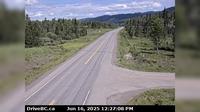
Crawford Bay › North: Hwy 31, 45 km north of Nelson and 25 km south of Kaslo, looking north | Live Webcams
Webcam & Weather Report
See.cam
North America
CA
British Columbia
Crawford Bay
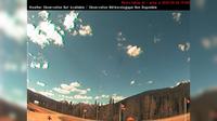
Crawford Bay › North: Hwy 31, 45 km north of Nelson and 25 km south of Kaslo, looking north
Current Still
Timelapse
Daylight Still
Webcam was last updated 2 years ago
Rating
Webcam Views
Map
Discuss
See more webcams in
British Columbia
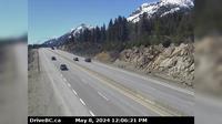
Northern Rockies Regional Municipality › South-West: MunchoLake
Regional District of Bulkley-Nechako › West: Hwy at Augier Rd, about km east of Burns Lake, looking west
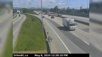
West Kelowna › North: Hwy 97 at Hwy 97C junction, about 5 km south of Westbank, looking north
East Central Okanagan Electoral Area › South-West
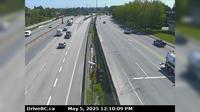
Abbotsford › South: Hwy 1 at Clearbrook Rd, looking south
British Columbia: Calvert Island: West Beach Lookout
Houston › North-West: Hwy 16 at Anderson Road, 14 km NW of - looking north-west
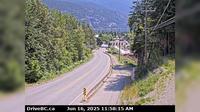
Kaslo › South-East: Hwy 31 at Hwy 31A Junction in - looking southeast
Fraser Valley Regional District › South-West: , Hwy , km south of Merritt, looking south
Delta › East: Hwy 91 at Fraserwood Way, on the East-West Connector, looking east
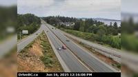
Sidney › North: Hwy 17 at McTavish Road, looking north
Delta › East: Hwy 91A at Gifford Street, looking east
Explore by Continent
Europe
Asia
South America
Oceania
North America
Africa


Discuss