Live Cams
Countries
Featured Cams
Get A Cam
Live Cams
Countries
Featured Cams
Get A Cam
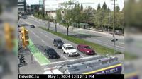
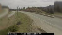
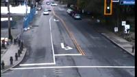
Juan de Fuca Electoral Area › North: Hwy 1 at Okotoks Road, looking north | Live Webcams
Webcam & Weather Report
See.cam
North America
CA
British Columbia
Juan de Fuca Electoral Area
Juan de Fuca Electoral Area › North: Hwy 1 at Okotoks Road, looking north
Current Still
Timelapse
Daylight Still
Webcam was last updated 2 years ago
Rating
Webcam Views
Map
Discuss
See more webcams in
British Columbia
Saanich › West: Hwy 17, Blanshard St at - Rd, looking west
Fauquier › East: Hwy 6 at front Needles Ferry Landing line up, looking east
Delta › West: Hwy 91A at Boundary Road, looking west
West Vancouver › North
Thompson-Nicola Regional District › North: , Hwy at Larson Hill, km south of Merritt, looking north
Pitt Meadows › North
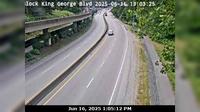
Bridgeview › West: Hwy 99A (King George Blvd) near 132nd St, looking west
Delta › East: Hwy 91 Connector at Nordel Way, looking east
Richmond › North
Kaleden › North: Hwy 97 at Hwy 3A junction, just south of - Weigh Scale, looking north
Area H
Abbotsford › West: Hwy 1 at Cole Road Rest Area, looking west
Explore by Continent
Europe
Asia
South America
Oceania
North America
Africa


Discuss