Live Cams
Countries
Featured Cams
Get A Cam
Live Cams
Countries
Featured Cams
Get A Cam
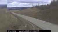
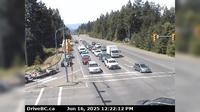
Juan de Fuca Electoral Area › East: Hwy 14 near Cormorant Way/Trailhead Dr, looking east | Live Webcams
Webcam & Weather Report
See.cam
North America
CA
British Columbia
Juan de Fuca Electoral Area
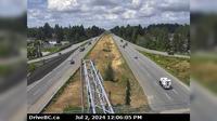
Juan de Fuca Electoral Area › East: Hwy 14 near Cormorant Way/Trailhead Dr, looking east
Current Still
Timelapse
Daylight Still
Webcam was last updated 2 years ago
Rating
Webcam Views
Map
Discuss
See more webcams in
British Columbia
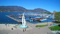
Kelowna: Sails and downtown pier
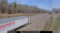
Charlie Lake › South-West: Hwy 29, 29 km west of Ft. St. John, looking southwest
Area C
Port Coquitlam › East: Hwy 7B/Mary Hill Bypass at Shaughnessy St looking east
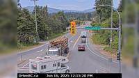
Courtenay › West: Intersection of Ryan Rd and Lerwick Rd in - looking west
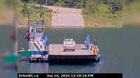
Area K › North: Hwy 6 at South Arrow Park Ferry Terminal, 22km south of Nakusp at junction of Upper and Lower Arrow Lakes, looking at north landing
Taylor › North: Hwy 97 at South - Hill, 20 km south of Fort St John, looking north
North Cowichan › West: Hwy 1, at Herd Rd/Cowichan Valley Hwy, about 5 km north of Duncan, looking west
Abbotsford › West: Hwy 1 at McCallum Road overpass, looking west
Kaslo › South-East: Hwy 31 at Hwy 31A Junction in - looking southeast
Slocan › South: Hwy 6 at Kennedy Rd/Lemon Creek Rd, looking south near Lemon Creek, about 8km south of
Area B › North-East: Hwy 1, at Victoria Street in Yale, looking north
Explore by Continent
Europe
Asia
South America
Oceania
North America
Africa


Discuss