Live Cams
Countries
Featured Cams
Get A Cam
Live Cams
Countries
Featured Cams
Get A Cam
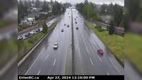
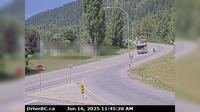
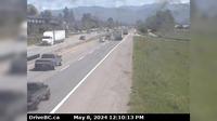
Mission › South: Hwy 7 at Hwy 11 approaching - looking south | Live Webcams
Webcam & Weather Report
See.cam
North America
CA
British Columbia
Mission
Mission › South: Hwy 7 at Hwy 11 approaching - looking south
Current Still
Timelapse
Daylight Still
Webcam was last updated 2 years ago
Rating
Webcam Views
Map
Discuss
See more webcams in
British Columbia
District of North Vancouver › East: Hwy 1 (Upper Levels Highway) at Westview Dr. looking east
Area A › East: Hwy 1, about 3.7 km south of Bamberton, looking east
Lake Cowichan › West: Hwy 18, at Skutz Falls Road, looking west
Nanaimo › North: Hwy 19 at College Drive, looking north
Canal Flats › North: Hwy 93 at Burns Avenue, looking south on Hwy
Salmo › West: Hwy 3 at Hwy 6, looking west on Hwy
Area F
Lantzville › North: Hwy 19, at Aulds Rd in Nanaimo, looking north
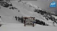
Fernie: Cedar Bowl View From Great Bear Top 1.680m - Coal
Abbotsford › East: Sumas Way
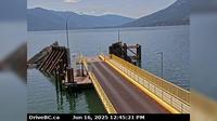
Area A › South-West: Kootenay Bay Ferry Landing, looking southwest to ferry ramp
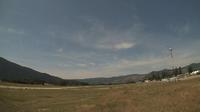
Grand Forks › West: Grand Forks Airport
Explore by Continent
Europe
Asia
South America
Oceania
North America
Africa


Discuss