Live Cams
Countries
Featured Cams
Get A Cam
Live Cams
Countries
Featured Cams
Get A Cam
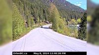
Peachland › West: Hwy 97C (Okanagan Connector), about 22 km west of 97/97C Jct, looking west | Live Webcams
Webcam & Weather Report
See.cam
North America
CA
British Columbia
Peachland
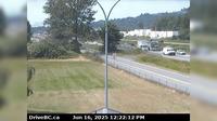
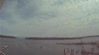
Peachland › West: Hwy 97C (Okanagan Connector), about 22 km west of 97/97C Jct, looking west
Current Still
Timelapse
Daylight Still
Webcam was last updated 2 years ago
Rating
Webcam Views
Map
Discuss
See more webcams in
British Columbia
Abbotsford › West: Hwy 1 at Cole Road Rest Area, looking west
Mackenzie › East: Hwy 97 at Hwy 39, about 29 km south of - looking east
Area J › South-West: Hwy 97D (Logan Lake/Lac le Jeune Rd) at Hwy 5, looking southwest
Keremeos › West: Hwy 3 at - Bypass Rd, looking west
Area D › East: Hwy 4 about 37 km west of Port Alberni at turn off for Taylor River Rest Area, looking east
Delta › South-West: Hwy 17 (South Fraser Perimeter Rd) at 80th Street, looking west
Columbia-Shuswap Regional District › East: , Hwy near the Perry River Bridge, about km east of Sicamous, looking east
Saanich › North: Hwy 1 at Helmcken Overpass looking north
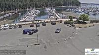
Nanaimo: Harbour northeast
Nanaimo › North
Golden › South-East
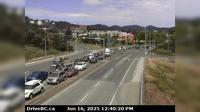
Langford › North: Hwy 1 at the Millstream Interchange, looking north
Explore by Continent
Europe
Asia
South America
Oceania
North America
Africa


Discuss