Live Cams
Countries
Featured Cams
Get A Cam
Live Cams
Countries
Featured Cams
Get A Cam
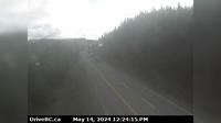
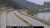
Summerland › South: Hwy 97 at Callan Rd, about 6 km north of - about 15 km south of Peachland. Looking south | Live Webcams
Webcam & Weather Report
See.cam
North America
CA
British Columbia
Summerland
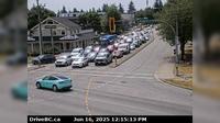
Summerland › South: Hwy 97 at Callan Rd, about 6 km north of - about 15 km south of Peachland. Looking south
Current Still
Timelapse
Daylight Still
Webcam was last updated 2 years ago
Rating
Webcam Views
Map
Discuss
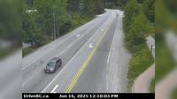
See more webcams in
British Columbia
Regional District of Bulkley-Nechako › East: Hwy , about km east of Burns Lake, looking east
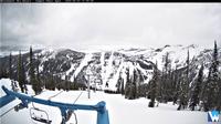
Whistler Creekside › North: Hwy 99, in Whistler at Lake Placid Rd, looking north
Area E › North-East
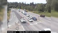
Mary Hill › West: Hwy 7B - Bypass), at Broadway St in Port Coquitlam, looking west
Britannia Beach › South: Hwy 99 in - at Copper Drive, looking south
Surrey › East: Hwy 10 at 152<sup>nd</sup> Street, looking east on Hwy
Oliver › West: Hwy 3, next to Conifryd Lake, looking west
Queens Park › North: Pattullo Bridge at north end, in New Westminster, looking north
Pitt Meadows › South: Hwy 7 (Lougheed Hwy) at Harris Road, looking south
Whistler Resort Municipality › East: Hwy 99 at Cheakamus Lake Rd & Alpha Lake Rd, 5 km south of Whistler, looking east
Saanich › South: Hwy 17 northbound at - Rd, looking south
Invermere › West: On Toby Creek Road at Panorama Fire Hall, near Springs Creek Rd, looking west
Explore by Continent
Europe
Asia
South America
Oceania
North America
Africa


Discuss