Live Cams
Countries
Featured Cams
Get A Cam
Live Cams
Countries
Featured Cams
Get A Cam
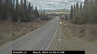
Vancouver › North: False Creek Fuels | Live Webcams
Webcam & Weather Report
See.cam
North America
CA
British Columbia
Vancouver
Vancouver › North: False Creek Fuels
Current Still
Timelapse
Daylight Still
Webcam was last updated 2 years ago
Rating
Webcam Views
Map
Discuss
See more webcams in
British Columbia
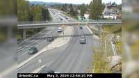
Saanich › North-West: Hwy 1 at Carey Rd, looking northwest
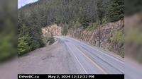
Boston Bar › North: Hwy 1 at Bradley Hill, about 3.5 km south of Hells Gate, looking north
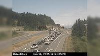
Nanaimo › North: Hwy 19 at College Drive, looking north
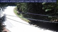
Area B: Gabriola Ferry Cam
Topley › West: On Hwy 16, 39 km west of Burns Lake looking west
Area B › North: Hwy 37N at Kitwancool Access Rd about 2.5 km south of Gitanyow and 21 km north of Hwy 16 junction, looking north
Area A › South-West: BellaBella
Dease Lake: Airport E
View Royal
Burns Lake › South: Hwy 16, in - at N. Francois Hwy, looking south
100 Mile House › North: Begbie Summit - Cariboo Highway
North Cowichan › East: Hwy 1, at Herd Rd/Cowichan Valley Hwy, about 5 km north of Duncan, looking east
Explore by Continent
Europe
Asia
South America
Oceania
North America
Africa


Discuss