Live Cams
Countries
Featured Cams
Get A Cam
Live Cams
Countries
Featured Cams
Get A Cam
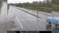
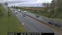
Vanderhoof › East: Hwy 16 at Hwy 27 Junction, looking east | Live Webcams
Webcam & Weather Report
See.cam
North America
CA
British Columbia
Vanderhoof
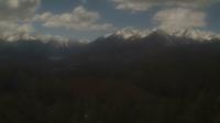
Vanderhoof › East: Hwy 16 at Hwy 27 Junction, looking east
Current Still
Timelapse
Daylight Still
Webcam was last updated 2 years ago
Rating
Webcam Views
Map
Discuss
See more webcams in
British Columbia
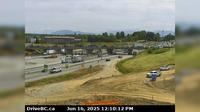
Campbell River › South: Hwy 19 at Willis Rd, about 2.5 km south of - looking south
Abbotsford › North
Area B › South: BlueRiver
Brighouse › North: Hwy 99, looking north from Steveston interchange
Burnaby › West: Hwy 91 at No.8 Road on East-West Connector, looking west
Salmon Valley › South: Hwy 97, north of Prince George at - Rd, looking south
Area F › South: South Shore Rd at Pacific Marine Rd, looking south
Quesnel › North: Hwy 97, at Sales Rd, about 10 km south of - looking north
Surrey › South: Hwy 99 near - USA border, looking south
Courtenay › North: Intersection of Ryan Rd and Lerwick Rd in - looking north
Area A › South
Abbotsford › East: 264 Street - Trans-Canada Highway
Explore by Continent
Europe
Asia
South America
Oceania
North America
Africa


Discuss