Live Cams
Countries
Featured Cams
Get A Cam
Live Cams
Countries
Featured Cams
Get A Cam
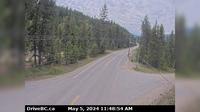
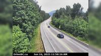
Wells › West: Hwy 26, near - about 78 km east of Quesnel, looking west | Live Webcams
Webcam & Weather Report
See.cam
North America
CA
British Columbia
Wells
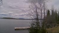
Wells › West: Hwy 26, near - about 78 km east of Quesnel, looking west
Current Still
Timelapse
Daylight Still
Webcam was last updated 2 years ago
Rating
Webcam Views
Map
Discuss
See more webcams in
British Columbia
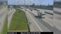
Delta › East: Hwy 91A at Gifford Street, looking east
Regional District of Kitimat-Stikine: Bob Quinn Lake SE
Slocan › South: Hwy 6 at Kennedy Rd/Lemon Creek Rd, looking south near Lemon Creek, about 8km south of
Cache Creek › East: Hwy 1 at Collins Rd, looking east on Hwy 1/97
Area L
Kamloops › West: Hwy 5 at Halston Ave - Paul Lake Rd in - looking west
Bridgeview › East: Pattullo Bridge at south end, in Surrey, looking east
Harrison Hot Springs › West: Hwy 1 at Herrling Island overpass westbound, looking west
Chilliwack › North: Hwy 9, at the north end of Rosedale Overhead, looking north
Hagensborg › North-East: Bella Coola Airport NE
Regional District of Bulkley-Nechako: Burns Lake Airport W
North Cowichan › North: Hwy 1, at Herd Rd/Cowichan Valley Hwy, about 5 km north of Duncan, looking north
Explore by Continent
Europe
Asia
South America
Oceania
North America
Africa


Discuss