Live Cams
Countries
Featured Cams
Get A Cam
Live Cams
Countries
Featured Cams
Get A Cam
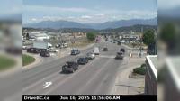
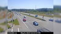
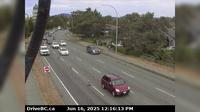
Area A › North: Hwy 1, at Vowels Rd next to Nanaimo Airport, looking north | Live Webcams
Webcam & Weather Report
See.cam
North America
CA
British Columbia
Area A
Area A › North: Hwy 1, at Vowels Rd next to Nanaimo Airport, looking north
Current Still
Timelapse
Daylight Still
Webcam was last updated 2 years ago
Rating
Webcam Views
Map
Discuss
See more webcams in
British Columbia
Cranbrook › North-East: Hwy 3/95 at 9th Ave. in - looking northeast
Area E › North: Hwy 33, about 14 km north of Westbridge and 20 km south of Beaverdell, looking north
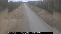
Area A › South: Hwy 101, about 8.5 km south of Lund, looking south
Surrey › South: Hwy 15 at Fraser Hwy (1A) looking south
Nanaimo › South: Hwy 19 at Northfield Rd in - looking south
Area L
Delta › South: Hwy 99 at Hwy 17A overpass, looking south to Hwy 17A
Whistler Resort Municipality › East: Hwy 99 at Cheakamus Lake Rd & Alpha Lake Rd, 5 km south of Whistler, looking east
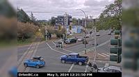
Saanich › North: Hwy 17 (Patricia Bay Highway) at Ravine Way, looking north
Topley › North: Granisle Hwy (Hwy 118), near summit. Approximately 14.5 km north of - looking north
Langford › East: Hwy 14 (Veteran's Memorial Parkway) at Goldstream Ave in - looking east
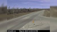
Peace River Regional District › North: , Hwy at Beaton Highway, km north of Fort St. John, looking north
Explore by Continent
Europe
Asia
South America
Oceania
North America
Africa


Discuss