Live Cams
Countries
Featured Cams
Get A Cam
Live Cams
Countries
Featured Cams
Get A Cam
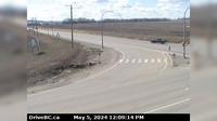
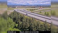
Port Edward › East: Hwy 16, next to the Skeena River, about 70 KM east of Prince Rupert, looking east | Live Webcams
Webcam & Weather Report
See.cam
North America
CA
British Columbia
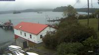
Port Edward
Port Edward › East: Hwy 16, next to the Skeena River, about 70 KM east of Prince Rupert, looking east
Current Still
Timelapse
Daylight Still
Webcam was last updated 2 years ago
Rating
Webcam Views
Map
Discuss
See more webcams in
British Columbia
Tofino › North-West: Opitsat - Lone Cone - Catface Peak
Gibsons › North-East: Hwy 101, top of - Bypass at Stewart Rd, looking east
Nanoose Bay › East: Hwy 19 at Northwest Bay Rd, near - looking east
Northern Rockies Regional Municipality › South-West: MunchoLake
Dawson Creek › South: Hwy 97 at Dangerous Goods Route, west of - looking south
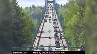
District of North Vancouver › South: North end of Lions Gate Bridge, looking south
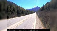
Hope › East: Hope Slide, BC - Mount Potter - Sunshine Valley - Mount Outram
Kamloops
Area D › North
Delta › East: Hwy 17 (South Fraser Perimeter Rd) at Deltaport Way in South - looking east
Regional District of Fraser-Fort George › East: Hwy at Dunster Station Rd, about km east of McBride, looking east
Area E › South-West: Hwy 3A & Hwy 31 at Balfour inland ferry terminal entrance of Ferry Landing Road, looking west
Explore by Continent
Europe
Asia
South America
Oceania
North America
Africa


Discuss