Live Cams
Countries
Featured Cams
Get A Cam
Live Cams
Countries
Featured Cams
Get A Cam
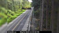
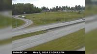
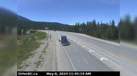
Columbia-Shuswap Regional District › West: , Hwy , by Griffin Lake, about km west of Revelstoke, looking west | Live Webcams
Webcam & Weather Report
See.cam
North America
CA
British Columbia
Taft
Columbia-Shuswap Regional District › West: , Hwy , by Griffin Lake, about km west of Revelstoke, looking west
Current Still
Timelapse
Daylight Still
Webcam was last updated 6 years ago
Rating
Webcam Views
Map
Discuss
See more webcams in
British Columbia
Area C › East: Hwy 19 near Hyde Creek Rd, 4.5km south of Port McNeill, looking east
Grandview › West: Hwy 15 at 24th Ave, looking west
Pitt Meadows › North
Delta › North: Hwy 99 from Hwy 17A overpass, looking northbound
Surrey › West: Hwy 99 at 8th Avenue in White Rock, looking west at southbound ramp from 8th Ave
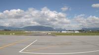
Merritt: Airport, BC
New Westminster › West: Hwy 1 in Coquitlam, west of the Brunette Ave overpass, looking west
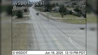
Cedarvale › East: Junction of Hwy 16 and Hwy 37, near Kitwanga, looking east on Hwy
Columbia-Shuswap Regional District › West: , Hwy , about km north of Golden at Donald Bridge, looking west
Osoyoos › South: US 97 at MP 336.4: (View South)
Area A › West: Hwy 1 at South Shawnigan Lake Rd, looking west
Area C: Mount Arrowsmith
Explore by Continent
Europe
Asia
South America
Oceania
North America
Africa


Discuss