Live Cams
Countries
Featured Cams
Get A Cam
Live Cams
Countries
Featured Cams
Get A Cam
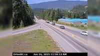
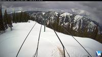
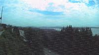
Area A › South-East: Hwy 1 at Field Access Road, about 16 km west of BC/Alberta border, looking southeast | Live Webcams
Webcam & Weather Report
See.cam
North America
CA
British Columbia
Area A
Area A › South-East: Hwy 1 at Field Access Road, about 16 km west of BC/Alberta border, looking southeast
Current Still
Timelapse
Daylight Still
Webcam was last updated 2 years ago
Rating
Webcam Views
Map
Discuss
See more webcams in
British Columbia
Playmor Junction › West: Hwy 6 at Hwy 3A in - looking west
Atlin › South
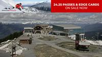
Whistler Resort Municipality: Blackcomb Peak
New Denver › West: Hwy 31A, at Retallack between - and Kaslo, looking west
Elkford › North: Hwy 43 at Fording River Road in - looking north
Area E: Whitewater Ski Resort
Mission › North: Hwy 7 (Lougheed Hwy) at Hayward St in - looking north-east along Hayward St
New Hazelton › East: Hwy 16 at McLeod St in - looking east
Regional District of Kitimat-Stikine › West: Hwy (Nass Rd) about km southwest of Village of Laxgalts'ap (Greenville), looking west
North Vancouver: West Vancouver 2
Hope › East: Hwy 1 at Hunter Creek, looking east
Smithers › West: Hwy 16 at Toronto Street in - looking west
Explore by Continent
Europe
Asia
South America
Oceania
North America
Africa


Discuss