Live Cams
Countries
Featured Cams
Get A Cam
Live Cams
Countries
Featured Cams
Get A Cam
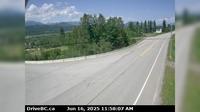
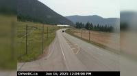
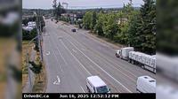
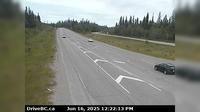
Peace River Regional District › North: , Hwy at Beaton Highway, km north of Fort St. John, looking north | Live Webcams
Webcam & Weather Report
See.cam
North America
CA
British Columbia
Buick
Peace River Regional District › North: , Hwy at Beaton Highway, km north of Fort St. John, looking north
Current Still
Timelapse
Daylight Still
Webcam was last updated 6 years ago
Rating
Webcam Views
Map
Discuss
See more webcams in
British Columbia
Brisco › North: Hwy 95 in - at - Road, looking north
Field › North-East: Hwy 1 at - Access Road, about 16 km west of BC/Alberta border, looking northeast
Delta › North: Hwy 99 from Hwy 17A overpass, looking northbound
Regional District of Bulkley-Nechako: Burns Lake Airport SE
Falkland › South-East: Hwy 97 at Silvernails Road near - looking southeast
Area B › North: Hwy 1 at Alexandra Bridge, looking north
Surrey › South-East: Hwy 17 at 104th Avenue looking southbound
Delta › South: 80th Street at Ladner Trunk Rd, looking south
City of Langley › South: Hwy 10 at 192 Street, looking south
Fraser Lake › West: Hwy 16, at Nautley Road, looking west
Fernie: Island Lake
Dease Lake › South-West: DeaseLake
Explore by Continent
Europe
Asia
South America
Oceania
North America
Africa


Discuss