Live Cams
Countries
Featured Cams
Get A Cam
Live Cams
Countries
Featured Cams
Get A Cam
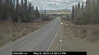
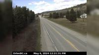
Burns Lake › South: Hwy 16, in - at N. Francois Hwy, looking south | Live Webcams
Webcam & Weather Report
See.cam
North America
CA
British Columbia
Burns Lake
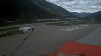
Burns Lake › South: Hwy 16, in - at N. Francois Hwy, looking south
Current Still
Timelapse
Daylight Still
Webcam was last updated 2 years ago
Rating
Webcam Views
Map
Discuss
See more webcams in
British Columbia
Topley › West: On Hwy 16, 39 km west of Burns Lake looking west
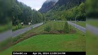
Harrison Hot Springs › East: Hwy 1 at Herrling Island overpass, westbound looking east
Hagensborg › North-East: Bella Coola Airport NE
Central Saanich › East: Hwy 17 at Mt Newton Cross Rd, looking east
North Saanich: Tsehum Harbour from Sidney - Yacht Club
Regional District of Kitimat-Stikine: Bob Quinn Lake SE
Kamloops › North
Revelstoke
Fraser Lake › West: Hwy 16 at Stella Road in - looking west
Haney › East: Northbound on Kanaka Way at Lougheed Highway
Nelson › North-East: Airport
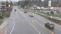
Abbotsford › South: Hwy 11 at Clayburn Road, looking south
Explore by Continent
Europe
Asia
South America
Oceania
North America
Africa


Discuss