Live Cams
Countries
Featured Cams
Get A Cam
Live Cams
Countries
Featured Cams
Get A Cam
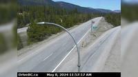
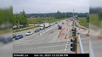
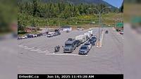
Charlie Lake › South-West: Hwy 29, 29 km west of Ft. St. John, looking southwest | Live Webcams
Webcam & Weather Report
See.cam
North America
CA
British Columbia
Charlie Lake
Charlie Lake › South-West: Hwy 29, 29 km west of Ft. St. John, looking southwest
Current Still
Timelapse
Daylight Still
Webcam was last updated 2 years ago
Rating
Webcam Views
Map
Discuss
See more webcams in
British Columbia
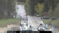
Fraser Valley Regional District › North: , Hwy , by Britton Creek Rest Area northbound turnoff, looking north
Area K › West: Hwy 6 at Needles Ferry Landing, looking west away from ferry landing towards Needles Rd N
Lake Country › South: Hwy 97, in - by Wood Lake, looking south
City of Langley › East: Hwy 10 at 192 Street, looking east
Surrey › South-East: Hwy 15 at Fraser Hwy (1A) looking south-east
District of North Vancouver › West: Hwy 1 (Upper Levels Highway) at Capilano Rd. looking west
Vancouver: Jericho Sailing Centre
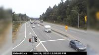
Saanich › East: Hwy 17 (Patricia Bay Highway) at Ravine Way, looking east
Area D › North
Procter › North: Balfour inland ferry terminal, looking north towards Hwy 3A
Harrop › North: Ferry Landing, on south side of Kootenay Lake, looking at the north side landing
Mill Bay › North: Hwy 1, approximately 3 km south of - looking north
Explore by Continent
Europe
Asia
South America
Oceania
North America
Africa


Discuss