Live Cams
Countries
Featured Cams
Get A Cam
Live Cams
Countries
Featured Cams
Get A Cam
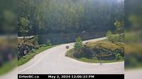
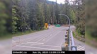
Pitt Meadows › South: Hwy 7 (Lougheed Hwy) at Maple Meadows Way/Dewdney Trunk Rd, looking south | Live Webcams
Webcam & Weather Report
See.cam
North America
CA
British Columbia
Pitt Meadows
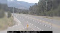
Pitt Meadows › South: Hwy 7 (Lougheed Hwy) at Maple Meadows Way/Dewdney Trunk Rd, looking south
Current Still
Timelapse
Daylight Still
Webcam was last updated 2 years ago
Rating
Webcam Views
Map
Discuss
See more webcams in
British Columbia
Harrison Hot Springs › South: Hwy 1 at Herrling Island overpass, looking south
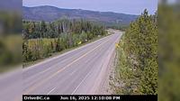
Princeton › North: Hwy 3, approximately 32 km south of - looking north
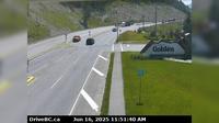
Golden › South-East
Golden › South-East: Hwy 1, at Hwy 95 interchange, looking east bound along Hwy
Whistler Resort Municipality › East: Hwy 99 at Cheakamus Lake Rd & Alpha Lake Rd, 5 km south of Whistler, looking east
British Columbia › West: Calvert Island West Beach
Chilliwack › South: Prest Rd at Hwy 1 in - looking south
Area H › North-West: ManningProvincialPark
Burnaby › North-East: Academic Quadrangle
Boothroyd 8A › North: Hwy 1 at Kahmoose Rd in Boothroyd, 12 km north of Boston Bar, looking north
Elko › North: Hwy 3, about 10km south of Fernie at Morrissey Jct, looking north
Delta › North: Hwy 91 at 72<sup>nd</sup> Ave. in - looking north
Explore by Continent
Europe
Asia
South America
Oceania
North America
Africa


Discuss